Bávaro Beach, Hour by Hour
Almost everything written about Bávaro Beach describes a photograph: white sand, turquoise water, a palm leaning over it. That is accurate and it is not much use, because the same shoreline behaves one way at seven in the morning and another at four in the afternoon, and differently again in March and in July. This guide is written from the far end of the coast. Crystal Garden's 196 residences sit inside Cap Cana, where Playa Caracol is about 1,800 ft away on foot and Juanillo Beach is 8 minutes by car, so Bávaro here is somewhere you drive to on purpose — and the useful question is not how far, but when.
Why “Bávaro Beach” means different things to different people
Bávaro Beach has no edges. It is not a park with an entrance, not a town with a boundary, and no authority publishes a line saying where it starts or stops. What exists is a long ribbon of sand on the east coast of the Dominican Republic and a set of place-names that people apply to overlapping parts of it.
The administrative picture explains much of the confusion. Bávaro is not a town in its own right: it has long sat inside the Verón–Punta Cana touristic municipal district, itself attached to the municipality of Higüey in the province of La Altagracia. Dominican legislators have spent years on a bill raising that district to a full municipality under the name Verón-Bávaro-Punta Cana; reporting in the Dominican press — Diario Libre and El Caribe both covered a first-reading approval in the Senate in 2025 — is the best public record of where that has reached, and it is what to check rather than us. Either way the point survives: the proposed name strings three place-names together, which is the clearest possible admission that they cover one another rather than marking three separate places.
So when a listing says Bávaro Beach, it is naming a shoreline, a general area, or simply a mood. None of those readings is wrong. It only means the name on its own tells you very little, while the sector tells you a great deal.
Reading the coast, north to south
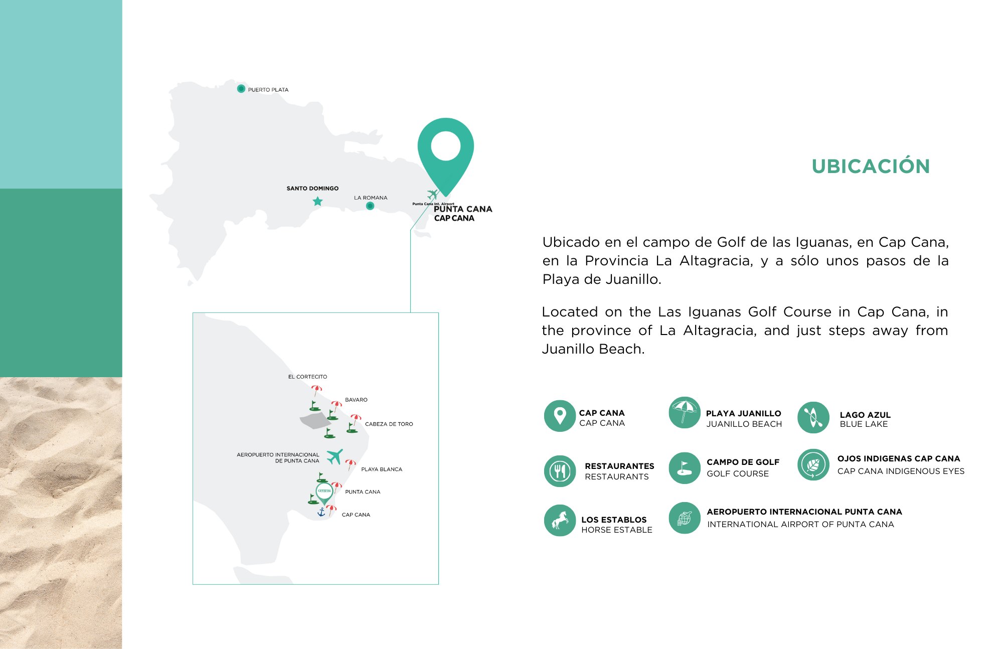
Put the names in order and the coast becomes legible. Coming down from the northern end toward the corner of the island, the sand passes Arena Gorda, then El Cortecito, then the stretch most people mean when they say Playa Bávaro, then Cabeza de Toro, where the shore begins to bend. Crystal Garden's own location board marks El Cortecito, Bávaro and Cabeza de Toro in exactly that sequence with Punta Cana and Cap Cana below them: the development stands at the far end of that line, past the corner the island turns at Cabo Engaño, inside Cap Cana on the Las Iguanas golf course.
What separates one sector from the next is rarely the sand. It is who is standing on it, what has been built behind it, and how freely the wind reaches it.
| The name you will see | What it usually refers to |
|---|---|
| Arena Gorda | The northern end of the run, and the name that turns up in Bandera Azul (Blue Flag) certification listings for this coast — held by whoever runs one managed section and renewed season by season, never by a whole beach. |
| El Cortecito | The informal, public end: walk-in entrances, small boats pulled up on the sand, plastic chairs at the waterline. |
| Playa Bávaro | The middle of the strip, largely hotel frontage, and the name most often stretched to cover the entire shoreline. |
| Cabeza de Toro | Where the shore starts to bend. Shallow water, side-shore wind, and the base for kite and windsurf schools. |
The morning sea and the afternoon sea are not the same water
This coast faces east, straight into the open Atlantic, and that single fact explains most of what a day on it feels like. The sun comes up out of the water rather than going down into it, so first light is the event here and the sunset happens behind you, over land.
A coral reef lies offshore along much of the shoreline and takes the energy out of the swell before it lands, which is why the water inshore reads as a shallow flat lagoon rather than as surf. What changes through the day is the wind. The easterly trade blows onshore and generally firms up as the land heats, so the glassy hour is early and chop is an afternoon habit — which is also why the kite and windsurf schools on this coast run their sessions late in the day rather than at dawn.
None of that is a forecast, and one windy sunrise will contradict all of it. The Oficina Nacional de Meteorología (ONAMET), the Dominican national weather service, is where to look for what a particular day is actually doing.
- First light The flat hour The sea is at its calmest and the sun rises out of the water. The swimming and photography window, on empty sand.
- Mid-morning The beach fills Loungers, vendors and boat trips get going. Natural shade is scarce until the palms come round.
- Early afternoon The trade wind arrives The onshore breeze firms up, the surface breaks into chop, and the kite and windsurf schools go out where it is reliable.
- Late afternoon The light turns The heat drops and the crowd thins while the water stays lively. Sunset is behind you over the land, not over the sea.
- After dark Not a swimming beach Lifeguard cover and lighting belong to whoever manages a particular section, so an open stretch is exactly as equipped as it looks. The evening happens on the strip behind the sand.
Sargassum, and how to check it yourself instead of asking
The seaweed question decides whether a trip is remembered fondly, and it deserves a straight answer: nobody can tell you what a given beach will look like on a given morning. Sargassum drifts across the Atlantic in enormous floating mats and comes ashore where wind and current put it, which on an east-facing coast means some years far more than others, heavy on one sector and barely present on the next one along the same day.
What does exist is a public, free, monthly outlook. The Optical Oceanography Lab at the University of South Florida runs the Sargassum Watch System and publishes a satellite-based bulletin describing how much sargassum is in the Atlantic and the Caribbean and what the coming weeks are likely to bring. Read it for the season rather than for your Tuesday: it is a basin-scale measurement and it cannot say which stretch of sand will be clear.
On the ground the difference between one section and the next is usually who clears it, and how early. That is a management question, which is why it varies so much along a shoreline that is continuous while the operators on it are not.
Planning the drive up, and what you are actually going for
From Cap Cana this is a drive and not a walk, and that is worth saying plainly, because beach-adjacency is the claim buyers most often take on trust. What Crystal Garden publishes is its own shore: Playa Caracol about 1,800 ft away, roughly a ten-minute walk, and Juanillo Beach 8 minutes by car, with Punta Cana International Airport around 20 minutes and Downtown Punta Cana about 30. Bávaro is not among those published times, so this page puts no figure on it — ask for a current door-to-door time rather than accepting one from a brochure.
What the drive buys is the version of this coast that a quiet shore does not have: open public sand with entrances anyone may use, watersports run commercially, boats leaving from the beach, and a working strip of shops, bakeries and pharmacies behind it. Go early for the flat water, plan to park at a public entrance rather than in front of a hotel, and be on the road home before the wind and the heat make the afternoon somebody else's.
For an owner who lets the property, the same honesty belongs in the listing. Crystal Garden's 196 residences are scheduled for delivery in 2027, with prices from $475,000. A guest who books expecting to step onto Bávaro sand from the door will be disappointed; one who books knowing it is a morning drive will not be.
Common questions
- Where does Bávaro Beach begin and end?
- There is no published boundary. Bávaro is a place-name for part of a continuous shoreline inside the Verón–Punta Cana touristic municipal district, under the municipality of Higüey in La Altagracia — not a beach with a gate or an official line on a map. In practice people navigate by sector: Arena Gorda at the northern end, El Cortecito, the middle stretch usually called Playa Bávaro, and Cabeza de Toro where the coast starts to bend.
- Is Bávaro Beach public?
- The sand is. Ley 305 of 1968 places the maritime zone — roughly the first 200 feet inland from the high-tide line — in public hands, and it cannot be sold or fenced off. Two consequences are less obvious. The strip is measured from the tide line, so its inland edge moves. And public ownership of the sand settles nothing about the land behind it: the access road, the car park, the path and the furniture can all be privately controlled, entirely lawfully. Never assume a property has a walking route to the water because a map looks short.
- Will there be seaweed when I visit?
- Nobody can promise either way for a particular week. The honest tools are seasonal: the University of South Florida's Optical Oceanography Lab publishes a free monthly Sargassum outlook from satellite data covering the Atlantic and the Caribbean, which tells you what kind of year it is rather than what your morning will look like. Sargassum is also patchy — one sector can be piled up while the next is clean the same day — so which section you choose matters as much as which month.
- How far is Bávaro Beach from Crystal Garden?
- The development publishes drive times for Downtown Punta Cana at about 30 minutes and Punta Cana International Airport at about 20, and Bávaro is not among them, so no figure appears here. What is published sits closer to home: Playa Caracol about 1,800 ft away, a ten-minute walk, and Juanillo Beach 8 minutes by car. Treat Bávaro as a planned outing rather than as the beach at the end of the road.
- When is the water calmest?
- Early. The coast faces east and the easterly trade wind generally strengthens as the day heats up, so flat glassy water is a morning condition and chop is an afternoon one. Check ONAMET, the Dominican national weather service, for the day itself — a seasonal pattern is not a forecast.
Want the details for your own situation?
Ask about availability, layouts or the buying process, and someone from the sales team will get back to you.
Get in touch